

| | |
Pardoe Trail
El Dorado National Forest (View this site)
Amador County, California
Amador County, California
Kirkwood, gas up in Jackson or South Lake Tahoe
Strawberry Pass and Deer Valley Trail
Blazen Off Road and Full Tilt 4x4 (South Lake Tahoe)
Strawberry Pass and Deer Valley Trail
Blazen Off Road and Full Tilt 4x4 (South Lake Tahoe)
Moderate
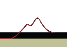
14.5 Miles
6,860' to 9,260'
Late Spring after snow melt
Squaw Ridge, Bear River Lake, Pardoe Lake,
Plasse Trading Post
14.5 Miles
6,860' to 9,260'
Late Spring after snow melt
Squaw Ridge, Bear River Lake, Pardoe Lake,
Plasse Trading Post
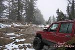
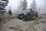
Trail Photographs
(click to view full size)
(click to view full size)
Pardoe Trail, also know as Squaw Ridge Trail, is very fun to drive as it twist and
turns along Squaw Ridge. From Bear River Reservoir to the 9,260' peak of
Squaw Ridge this trail offers seemingly endless views from nearly every
direction. There may be snow pack to break through as late as July and snow
fall on the peak as early as October.
While a majority of the trail can be run in two wheel drive there are two fun rock
gardens with the upper rock garden being the most challenging of the two. Most
stock high clearance vehicles with proper body protection will not have many
issues, although a mild lift is recommended for the upper section of the trail
past Plasse Trading Post. Allow a full day to enjoy this trail.
Bear River Lake Trail Access - The trail begins along the Southeastern
section of Bear River Reservoir. Exit Highway 88 onto Bear River Road and
cross the dam following the south end of the lake up the hillside. The only
marker for the trail is the U.S. Forest Service road marker for 8N03.
Pardoe Camp Road - As you start up the ridge side you will come across a
road junction to the right, this is the road to Pardoe Campground. While
camping is permitted along the trail there are several campgrounds along Bear
River Reservoir and Silver Lake. A section of the trail follows a corridor through
Mokelumne Wilderness land and a permit is required to camp along this
section.
Lower Rock Garden - As the lower rock garden begins the trail seems to
disappear at times over the granite slabs and rocks. This is the some of the
most difficult terrain of the trail. Although most stock four wheel drive vehicles
can make the trip, some may require more work than others. Remember when
stacking rocks to get over obstacles put them back after you have passed
through.
Plasse Trading Post - Part of the trail follows the historic Emigrant Trail and
trail markers share some insight to the history of this location. A marker depicts
a journal log from a traveler who met a trader here in 1852. This spot also
marks an easy route, road 17E19, back to Highway 88 and the most difficult
section of the trail is just beyond here.
Upper Rock Garden - Although this is the most difficult section of the trail it can
be easily navigated with a slightly modified vehicle. Early snow fall made it
difficult for us to find the trail on several sections and we had to walk ahead to
scout the trail. Keep an eye out for metal markers nailed to the trees.
Squaw Ridge Peak - A post with a marker quoting a journal log from a Silas
Newcomb citing his nights stay about one mile from the ridge. Squaw Ridge
offers some incredible views and marks the end of Pardoe Jeep Trail. From
Squaw Ridge a hiking path winds to the North over Covered Wagon Peak and
Service Road 17E21 will take you Northwest to the North shore of Silver Lake.
We were unable to find Service Road 17E21, an ATV route, due to the snow
cover. We recommend heading back down to Plasse Trading Post and taking
Service Road 17E19 to Highway 88 just South of Silver Lake.
Trail Maps
Waypoint Coordinates
(click to download)
(click to download)
38° 32' 51.3" N 120° 12' 10.6" W
38° 34' 23.8" N 120° 09' 59.9" W
38° 34' 20.0" N 120° 08' 37.8" W
38° 34' 56.4" N 120° 07' 58.5" W
38° 36' 02.8" N 120° 06' 26.1" W
38° 36' 53.0" N 120° 05' 24.5" W
38° 38' 02.1" N 120° 03' 23.5" W
38° 38' 43.5" N 120° 03' 10.1" W
38° 34' 23.8" N 120° 09' 59.9" W
38° 34' 20.0" N 120° 08' 37.8" W
38° 34' 56.4" N 120° 07' 58.5" W
38° 36' 02.8" N 120° 06' 26.1" W
38° 36' 53.0" N 120° 05' 24.5" W
38° 38' 02.1" N 120° 03' 23.5" W
38° 38' 43.5" N 120° 03' 10.1" W
Trialhead
Pardoe Camp Road
Mokelumne Wilderness
Lower Rock Garden
Plasse Trading Post
Service Road 17E19
Upper Rock Garden
Squaw Ridge Peak
Pardoe Camp Road
Mokelumne Wilderness
Lower Rock Garden
Plasse Trading Post
Service Road 17E19
Upper Rock Garden
Squaw Ridge Peak
Pardoe Trail & Waypoints (Google Earth)
GPS Track (GPX)
GPS Waypoint (GPX)
El Dorado National Forest (National Forest Service)
Bear River Reservoir (USGS 24K TOPO)
Caples Lake (USGS 24K TOPO)
Mokelumne Peak (USGS 24K TOPO)
GPS Track (GPX)
GPS Waypoint (GPX)
El Dorado National Forest (National Forest Service)
Bear River Reservoir (USGS 24K TOPO)
Caples Lake (USGS 24K TOPO)
Mokelumne Peak (USGS 24K TOPO)
Directions
From Highway 88 - Sacramento (84 Miles)
- Head East on Highway 16 toward Jackson (30 Miles)
- Turn right onto Highway 49 and continue South (9.8 Miles)
- Turn left onto Highway 88 in Jackson (36.7 Miles)
- Look for signs to Bear River Reservoir
- Turn right onto Bear River Road (6.7 Miles)
- Follow the road across the dam and turn left following the lake
- Look for the sign for Forest Service Route 8N03
From Highway 4 - South Lake Tahoe (56 Miles)
- Head South on Highway 50 (4.4 Miles)
- Turn left onto Highway 89 (11.2 Miles)
- Turn right onto Highway 88 (33.5 Miles)
- Look for signs to Bear River Reservoir
- Turn right onto Bear River Road (6.7 Miles)
- Follow the road across the dam and turn left following the lake
- Look for the sign for Forest Service Route 8N03
| All other products, logos, brand names or companies are trademarks or registered trademarks of their respective companies. |
4x4TrailMaps - All Rights Reserved
| Difficulty Rating: Total Trail Length: Elevation Change: Operating Season: Points of Interest: |
| Nearby Cities: Nearby Trails: Nearby Shops: |
Please allow a few moments to load...
| | |